


From Kibbutz to the global stage
Copper Scroll: From the Pool of Siloam to the Jordan River Basin and Qumran
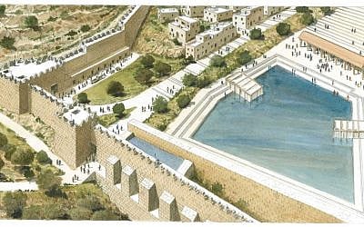
Trying to Decipher Section 47 of the Copper Scroll: A New Hypothesis on the Hidden Engineering of the Pool of Siloam.
Following the hydro-archaeological analysis that proposed identifying Section 46 of the Copper Scroll with the mysterious tunnel at Ramat Rachel, the geographical and textual focus now shifts several kilometers north. Section 47 of the Scroll presents an equally fascinating puzzle, potentially bridging the still-undeciphered Qumran text with the water infrastructure and urban life of Jerusalem during the Second Temple period.
The text of the Scroll — Section 47
“Beyam shel gei zakh, betzido hama’aravi, even shekhoria, amot shtayin hu hapetah, kikarim shlosh me’ot zahav, vekelim kofrim asarah.”
The fortifications and the actual depth on the ground
The phrase “the sea of the pure valley” (yam shel gei zakh) may point to the principal water reservoir fed by the Gihon Spring — the Pool of Siloam.
The “black stone” (even shekhoria) on its western side may not refer to a random rock, but rather to a monumental topographical landmark: the massive fortifications and spring tower overlooking the pool, whose stones may have darkened through weathering over time.
The expression “amot shtayin” is interpreted here as two cubits of water depth — approximately 80 centimeters net. This depth corresponds approximately to the depth suggested by the archaeological evidence on the ground and would have created roughly waist-deep water — a practical depth for walking, washing, and large-scale ritual immersion by pilgrims.
Water quality and volume: When the text meets engineering
The Scroll records a value of “300 gold.” According to the hypothesis proposed in our previous articles, “gold” (zahav) may refer here to clean, fresh water.
Under the engineering model we have proposed, which translates these units of value into a standardized water-volume measure of 10 cubic meters per unit, the resulting capacity would be approximately 3,000 cubic meters.
A morphological examination of the Pool of Siloam indicates an area ranging from approximately 3,000 to 5,000 square meters, depending on its different phases of expansion. Multiplying this area by an average water depth of 0.8 meters produces a physical storage volume ranging from approximately 2,400 to 4,000 cubic meters.
The Scroll-derived estimate of approximately 3,000 cubic meters therefore corresponds, in approximate order of magnitude, to the reservoir capacity suggested by the archaeological data.
Jerusalem’s entrance corridor and the pilgrims’ economy
The Pool of Siloam was not merely an engineering installation. It also served as an urban and social “entrance corridor” to Jerusalem during the three pilgrimage festivals — Passover, Shavuot and Sukkot.
Recovery and purification: The pool functioned as an urban oasis, providing thermal relief and refreshment in the cool waters of the Gihon, alongside large-scale ritual immersion before pilgrims ascended the stepped street toward the Temple Mount.
A center for the consumption of the Second Tithe: It may also have served as an important station for unloading provisions, redeeming money and converting it into food, wine and oil to be consumed in ritual purity in Jerusalem.
A global meeting place and ritual celebration: Pilgrims arriving from Babylonia, Alexandria, the Galilee and elsewhere converged in Jerusalem, while the Siloam area was closely associated with the water rituals surrounding the festival of Sukkot and the celebration known as Simchat Beit HaShoeva.
“Kelim kofrim”: Archaeological evidence and the end of the revolt
The expression “kelim kofrim asarah” — “ten sealed/coated vessels” — may combine practical and ritual meanings.
Kopher can refer to bitumen or another sealing material. Under this interpretation, these were pottery jars or containers coated and tightly sealed with pitch — “vessels coated with pitch,” in the terminology known from rabbinic literature — which could have been used to store offerings, wine and oil (demai), or redemption money in a wet environment without damage or contamination.
Coins dating to the fourth year of the revolt, 69 CE, discovered on the pavement provide chronological evidence for activity at the site shortly before the destruction of Jerusalem in 70 CE. The underground drainage channels beneath the area subsequently became a final refuge for people hiding from the Romans.
The apparent discrepancy between the Scroll’s documentation of valuables and the absence of gold at the site today may itself have a historical explanation. Gold, money and tithes could have been systematically looted by the Roman legions as they penetrated the hiding places, as Josephus describes in his account of the conquest, while cooking pots and pitch-coated pottery abandoned at the site remained as silent physical evidence of the economic and ritual system that operated there until the destruction.
From the Second Temple to the desert cliffs: How did the Scroll reach Qumran?
One major question has remained unresolved for decades: how did the Copper Scroll come to be deposited in the caves of Qumran, far from the places in Jerusalem where the valuables described in the Scroll have traditionally been sought?
As discussed in our previous analyses, based particularly on Section 60 of the Scroll, we propose that the logistical and operational center of the treasury administrators was located at the site called Kahlat — which we tentatively locate in the northeastern part of the Jordan River estuary, toward the foothills of the Moab Mountains in present-day Jordan.
During the Second Temple period, the surface of the Dead Sea stood approximately 100 meters higher than it does today.
Our hypothesis for the journey of the Copper Scroll from the Jordan River estuary to the caves of Qumran is as follows.
As Roman pressure intensified and Roman forces approached the operational refuge at Kahlat, a group of rebels or treasury administrators may have acted according to the instructions preserved in Section 60. They concealed the original records and documents in an underground hiding place beneath the local pool at Kahlat and carried with them a single emergency copy engraved on sheets of copper.
From there, according to our reconstruction, they descended to the shoreline, boarded a boat and sailed approximately 10 kilometers south across the Dead Sea toward the foot of the Qumran cliffs — which, during the early centuries of the Common Era, were much closer to the shoreline than they are today.
The fugitives could then have climbed the steep cliffs and deposited the copper copy in an isolated cave high above the shore — the cave now known as Cave 3 — where the Scroll remained protected for nearly two thousand years until its discover
About the Author
Rafi Glick is a writer, lecturer, farmer, and business executive with decades of experience at the intersection of academia, technology, agriculture, and international trade.
• He has served as a Senior Teaching Associate at Ben-Gurion University of the Negev, Ono Academic College, Ariel University, Ruppin Academic Center, and as a guest lecturer at Sofia University’s Faculty of Economics and Business Administration (FEBA). At Ben-Gurion University he also advised the BGU–NHSA Accelerator in the Faculty of Science.
• In business, Rafi was CEO of Bidsnet Ltd., a pioneer in deploying fiber-optic cables through unconventional infrastructure (in partnership with CableRunner), delivering high-speed connectivity to homes, enterprises, institutions, and cellular networks. Earlier he held senior roles at ECI Telecom and served on the board of RLF Venture Capital, working with partners such as Intel, Teva, and the Jerusalem Development Authority.
• He contributed extensively to Israel’s trade and investment ecosystem: he directed industrial and agricultural technology divisions at the Israel Export Institute, founded Israel’s AGRITECH as international exhibition, and served on the board of the Israeli Investment Center at the Ministry of Industry and Trade.
• In his early career, Rafi established and served as the first director of the Cargo and Aircraft Supply Security Department in the Security Division at Ben-Gurion Airport (1972–1976). He lived in Kibbutz Parod until 1974.
• Rafi has also been recognized for his writing: in 2008 he was named Best Economic Blogger by TheMarker, Israel’s leading business daily.
• Today he continues to publish essays and commentary—with a special passion for astrophysics, space exploration, technology, economics, and social issues.
From Kibbutz Parod to the global stage, Rafi Glick’s career reflects a lifelong commitment to building connections—between people, industries, and ideas.
Email: rafi.glick@gmail.com
Related Topics
Related Posts


Rafi Glick