From Kibbutz to the global stage
Jerusalem: Unknown Reservoirs in Absalom’s Tomb on Pilgrims’ way to Temple Mount
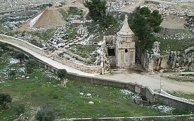
The Hidden Waterworks of the Kidron Valley: Do Sections 48–49 of the Copper Scroll Lead to Absalom’s Tomb and the Tomb of Jehoshaphat?
This article explores an attempt to decipher a mysterious and potentially extensive water installation beneath the western side of Absalom’s Tomb, possibly connected to a filtration and storage system beneath the “burial trough” in the nearby Tomb of Jehoshaphat (Sections 48 and 49 of the Copper Scroll).
In previous articles, we examined a runoff-collection installation within the perimeter system at Ramat Rachel (Section 46). We then moved northward along the Pilgrimage Road to the Pool of Siloam (Section 47). We now continue several hundred meters farther north through the Kidron Valley (Sections 48–49), approaching the outskirts of the Temple Mount (Section 50).
The section numbers used here follow the division of the Copper Scroll into 60 sections; other editions divide the text into 64 sections.
Strategic Engineering in Hezekiah’s Tunnel: The Curves as a Design Solution
Scholarly literature has often suggested that the winding course of Hezekiah’s Tunnel — extending its length to approximately 533 meters (1,200 cubits), compared with only about 300 meters in a straight line — resulted from planning errors or deviations by the excavators.
In our assessment, however, the bends and the raising of the southern opening to a height of approximately four meters may represent advanced strategic, hydrological, and defensive planning:
Connection to the eastern wall: Excavating the tunnel close to the inner wall may have allowed the integration of vertical and diagonal shafts leading toward and beyond the wall — for communication, ventilation, physical access, and the regulation of air and pressure within the water system.
Controllable acoustic communication:
The winding route may have improved the ability of the two excavation teams approaching from opposite directions to communicate acoustically.
Use of Channel 2:
Utilizing the earlier Canaanite Channel 2 along part of the route may have enabled accurate measurements and helped maintain the tunnel’s exceptionally gentle flow gradient of approximately 0.06%. The channel was later extended southward to fill the runoff-storage pool known as Birkat al-Hamra.
Preventing a direct line of fire: Avoiding a straight tunnel could have prevented direct arrow or spear fire in the event of enemy penetration through the water passages — a defensive lesson that may echo the biblical account of the Jebusite conquest of Jerusalem in the time of David.
Use of karstic fissures:
Connecting with natural fissures could have reduced the amount of difficult rock excavation while providing concealed routes for excess water during emergencies.
Hydraulic moderation — a form of shock absorption:
The bends could have reduced flow velocity when dams or barriers were opened during emergencies, helping prevent damage to infrastructure around the Pool of Siloam and Birkat al-Hamra. Raising the tunnel opening to approximately four meters may also have allowed the storage capacity to be tripled during a siege.
In our assessment, therefore, this system may not have been the product of error, but rather of sophisticated engineering designed for both normal conditions and emergencies.
The Absalom’s Tomb–Tomb of Jehoshaphat Complex: Sections 48–49
The Copper Scroll reads:
48. Tahat Yad Avshalom min ha-tzad ha-ma’aravi, hafor amot shtem-esreh, k.k. 80.
49. Beyam Beit ha-Mayim shel Yeho, le-tahat ha-shoket, k.k. 17.
Section 48 — The Proposed Reservoir at Absalom’s Tomb:
The text describes an excavation of 12 cubits — approximately 5.5–6 meters into the rock, and potentially about 10–12 meters below the present-day surface when the accumulated sediment is included — on the western side of the monument.
The proposed cavity would lie at a calculated elevation of approximately 677 meters above sea level. According to the hydraulic calibration proposed in the previous articles — one unit corresponding to approximately 10 cubic meters — the notation “k.k. 80” would predict a volume of approximately 800 cubic meters.
Under this hypothesis, the reservoir was intended to capture relatively clean runoff descending from the slopes of the Mount of Olives before it reached the bottom of the Kidron Valley.
Section 49 — The Proposed Identification with Part of the Tomb of Jehoshaphat Complex:
Using the same hydraulic calibration, the notation “k.k. 17” would correspond to a predicted volume of approximately 170 cubic meters, located “beneath the trough” — possibly directly beneath the rock-cut burial trough in the Tomb of Jehoshaphat.
Water Use Within a Burial Complex
The presence of a plastered chamber within the Tomb of Jehoshaphat complex raises an important question. Burial caves are not generally expected to contain hydraulic plaster or plaster specifically intended for waterproofing.
If it can be demonstrated that the plaster belongs to an early phase of the complex, it could point to a secondary or parallel hydraulic function.
Under our hypothesis, this smaller volume may have served as an initial settling and filtration basin associated with the larger reservoir, or alternatively as an independent water installation.
The physical proximity of these installations to the Temple Mount raises another intriguing question: could a concealed underground connection once have existed between these water systems and the Temple Mount, serving the extensive purification and cleaning requirements associated with the priestly complex?
A subsurface investigation could examine whether any rock-cut passage or other connection existed between the eastern side of the Temple Mount and these proposed reservoirs.
Conclusions and a Non-Invasive Testing Protocol
Testing for the existence of cavities and channels around the predicted elevation of 677 meters does not initially require physical excavation or interference with burial sites or the religious and archaeological status quo.
The engineering model could first be tested through a focused geophysical survey. Any cavity discovered may, of course, have served different functions during different periods — including, for example, the storage of tools or equipment used by priests or by those involved in burial activities.
Ground-Penetrating Radar (GPR): Low-frequency scanning (40–100 MHz) on the western side of Absalom’s Tomb could be used to search for cavities at depths of approximately 10–15 meters, while higher-resolution scanning (400–900 MHz) could be considered beneath the floor of the trough in the Tomb of Jehoshaphat.
Electrical Resistivity Tomography (ERT): Measurements of subsurface electrical properties could help distinguish between massive limestone, open cavities, and plastered or moisture-bearing spaces.
LiDAR mapping: Three-dimensional laser scanning of the external morphology could produce an accurate spatial model of the topography and gradients between the cliff and the eastern wall of the Temple Mount.
Combining GPR and ERT data with the elevation and gradient model could make it possible to construct a three-dimensional representation of the underground complex and provide preliminary evidence regarding the proposed water installations associated with Sections 48–49 and the nature of any cavities that may be identified — without physically disturbing the rock or the tombs.
At a later stage, if warranted by the results, decisions could be made regarding further research or archaeological excavation.
Related Topics