From Kibbutz to the global stage
Judean Desert: Are we Closer to Solving the Mystery of the Copper Scroll?
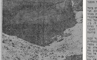
Source: LaMerhav, December 1, 1967, Historical Jewish Press collection, National Library of Israel.
The Copper Scroll: From a Treasure List to a National Infrastructure Survey?
1. Introduction: The Hydraulic Paradigm
Since its discovery at Qumran in 1952, the Copper Scroll (3Q15) has presented scholars with one of the most intriguing puzzles among the Dead Sea Scrolls. Does its list of dozens of locations and enormous quantities of “gold” and “silver” describe an imaginary treasure, a concealed Temple hoard, or perhaps an administrative code referring to tangible resources of a very different kind?
This article proposes examining the hypothesis that Sections 1–3 of the Copper Scroll are not descriptions of hidden precious metals, but rather the beginning of a survey and maintenance protocol for a regional water-infrastructure system in Judea during the late Second Temple period.
At the center of this proposed interpretation are three elements: a possible metrological calibration of water discharge and storage volumes, a solution to the geographical circularity of the survey, and an engineering distinction between different types of water resources across the region.
2. The Hydraulic Code and Metrological Calibration — Sections 1–3
We propose that, within the engineering language of the survey, the terms “gold” and “silver” may have served as qualitative and quantitative classifications of water resources.
“Silver” — surface runoff and flash-flood water: Seasonal water collected from wadis through dams, channels and storage systems — such as those associated with Wadi Qelt and Nahal Sekhakha — for infiltration, seasonal irrigation and reservoir replenishment.
“Gold” — reliable freshwater springs: The region’s highest-quality water resource: fresh, flowing and relatively dependable water supplied by productive karst springs.
“Ashtot” / “Kikkarin”: Units of volume or defined discharge measurements used for regulating and distributing water through channels and aqueducts.
A Proposed Conversion Factor and Quantitative Calibration
Comparison between the numerical information in the scroll and hydrological and archaeological data raises the possibility of a recurring 1:10 numerical conversion factor.
When a section concerns discharge, one textual unit may represent approximately 10 cubic meters per hour (m³/h). When a section concerns static storage, one textual unit may represent approximately 10 cubic meters (m³) of storage capacity.
Three comparisons are particularly noteworthy:
Section 1 — “Ba-haruvah she-be-Emek Akhor … shidat kesef”
(“In the ruin in the Valley of Achor … a container of silver.”)
Under the proposed hydraulic interpretation, this section describes the capture and storage of runoff and flash-flood water — “silver” — in the Achor basin through the northern water channels.
Section 2 — “Ba-nefesh, ba-nidbakh ha-shlishi, ashtot zahav 100”
(“In the monument, in the third course, 100 ingots of gold.”)
We propose that this may refer to the major freshwater complex of Ein Auja and the Na’aran springs — including Duyuk, Nueima and Shushan.
The scroll records 100 units of “gold.” Applying the proposed conversion factor produces 1,000 m³/h, corresponding to the peak combined discharge of this spring system.
A second comparison may provide an independent test of the same numerical relationship. In corresponding sections associated with the Wadi Qelt system, the scroll records 40 units. Applying the same conversion factor produces 400 m³/h, corresponding to the known average discharge of the Wadi Qelt springs.Section 3 — “Ba-bor ha-gadol, ba-hatzer ha-peristylon … kikkarin tesha me’ot”
(“In the great cistern, in the peristyle courtyard … 900 talents.”)
We propose that this section may refer to the storage pools in the courtyard complex of Herod’s palace at Jericho.
The scroll records 900 units. Under the proposed storage conversion, this corresponds to approximately 9,000 m³ — the estimated storage capacity of the pools.
These three comparisons do not in themselves prove a hydraulic code. They do, however, offer a quantitative hypothesis that can be tested against additional sections in the scroll and against independent archaeological and hydrological data.
3. A Circular Route — and a Possible Solution to the “Mount Gerizim Anomaly” (Sections 57–59)
We propose examining the Copper Scroll not as a random sequence of hiding places, but as a continuous hydro-topographical survey route.
The route may have followed a broad circuit:
Starting point: The northern Jericho basin and southern Jordan Valley — Ein Auja, Na’aran and the Valley of Achor.
The southern circuit: Qumran, Hyrcania, Nahal Sekhakha, Herodium, Koziba, Solomon’s Pools, Jerusalem, the Kidron basin and the Horon watershed.
Ascent to the head of the watershed: Mount Gerizim — Section 57.
Closing the circle: Descent through the drainage routes of Samaria and Mount Gerizim — including Wadi Fasa’il, Wadi Far’a and Wadi Yitav/Auja — in Sections 58–59, returning toward northern Jericho and finally the Jordan River’s outlet into the Dead Sea, identified in our hypothesis with Kahlat.
The Hydro-Political Significance of Mount Gerizim
For decades, the appearance of Mount Gerizim near the end of the Copper Scroll has been difficult to reconcile with many proposed treasure itineraries.
The hydraulic paradigm offers another possibility.
Mount Gerizim and the mountains of Samaria form part of the upper watershed feeding aquifers, springs and drainage systems descending toward the Jordan Valley.
Control of the water systems supplying Jericho and the valley therefore could not have depended only on infrastructure downstream. It also required knowledge of — and potentially control over — the upper drainage basin.
Under this interpretation, the ascent toward Mount Gerizim in Section 57 and the subsequent descent through spring and drainage routes in Sections 58–59 do not describe the movement or concealment of treasure.
They may instead describe an inspection of upstream water-control infrastructure, completing an engineering circuit that returns toward Ein Auja and Kahlat.
4. Field Evidence and Morphology: The Mystery of the Nahal Sekhakha Dam
The hypothesis of a regional infrastructure system described in the scroll can also be examined against archaeological and geomorphological evidence on the ground.
The Missing Dam
Photographs associated with the Allegro expedition in 1960, together with a 1967 report by Israeli archaeologist and journalist Zvi Ilan, point to the existence of a substantial dam at Nahal Sekhakha, north of Hyrcania.
We propose that the dam may have had a dual hydraulic function.
First, it could have regulated and transferred water toward the southern bank and the intake points of the northern channel system.
Second, excess runoff could have been diverted toward agricultural areas in the Hyrcania Valley.
If this interpretation is correct, the dam was not an isolated structure but part of a broader system for capturing, regulating, distributing and infiltrating seasonal floodwater.
Could “Tomb” Be a Hydraulic Metaphor?
Another term that deserves reconsideration is “kever” — “tomb.”
In the conventional reading, the term naturally suggests a burial structure. But within a hydraulic interpretation, it is worth testing whether at least some occurrences could refer metaphorically or technically to underground structures — such as infiltration shafts, settling basins or subterranean chambers — designed to capture flash-flood water and allow its controlled infiltration into the aquifer.
This possibility should be tested archaeologically rather than assumed linguistically. If structures with similar morphology can be identified at several locations where the scroll uses the same terminology, the hypothesis would become significantly stronger.
5. Does Section 60 Describe an “Operational Government”?
The final section of the Copper Scroll may be especially important.
Section 60 describes the placement of a “sefer meforash” — an explanatory or detailed document — together with the “mispar ve-heshbon shel ha-kol” — the number and accounting of everything — at a concealed, architecturally defined location, “under the northern corner of the east,” in the area identified in our hypothesis as Kahlat, near the Jordan River’s outlet into the Dead Sea.
Rather than another treasure cache, could this have been an engineering-administrative archive?
Such an archive could have contained the master records needed to inspect, restore, regulate and allocate the water system during both normal times and emergencies.
This interpretation suggests four dimensions of what might be called an “operational government”:
1. Water as the source of life.
Reliable water was a prerequisite for every settlement, orchard, agricultural community and military force operating along the desert frontier.
2. Water as an instrument of control.
Whoever controlled the upstream diversion points, dams and distribution infrastructure possessed a powerful instrument of authority.
3. Water allocation as a possible fiscal mechanism.
If agricultural water was centrally measured and allocated, control over water could also have provided an efficient mechanism for collecting dues or taxes from agricultural production. One possibility worth investigating is whether standardized hydraulic allocations had any relationship to the tithe system. At present, however, this remains a hypothesis requiring independent evidence before a direct numerical relationship can be established.
4. The “operational government.”
We propose examining whether a professional body of engineers, surveyors and administrators maintained standards at the beginning of the system, documented infrastructure along the route described in Sections 1–59, and preserved the overall water balance and accounting records in the central archive described in Section 60.
Conclusion
More than seventy years after its discovery, the Copper Scroll continues to demand examination from different perspectives. Despite decades of searches and speculation, no physical evidence has been found that establishes the existence of the enormous legendary treasure apparently described by the scroll.
That absence does not prove that the conventional interpretation is wrong. It does, however, justify testing alternative explanations.
The perspective proposed here is that the Copper Scroll may be read not simply as a treasure inventory, but potentially as something very different: a foundational record, a set of operating standards and an accounting ledger for a regional water and infrastructure administration in Judea during the late Second Temple period.
The hydraulic interpretation offers a potentially unified mathematical, topographical and administrative logic for the document.
Most importantly, it is testable.
The proposed 1:10 numerical relationship can be examined against additional sections of the scroll. The geographical sequence can be mapped against ancient watersheds, springs, aqueducts, dams and reservoirs. Sites associated with recurring terminology can be examined for common hydraulic morphology. And the proposed route can be compared with the actual hydrology of Judea, Samaria and the Jordan Valley.
If these independent tests repeatedly produce the same pattern, the Copper Scroll may ultimately tell us not where ancient Judea hid its treasure — but how it managed its most valuable resource: water.
Related Topics
Related Posts