From Kibbutz to the global stage
Baptism 2030: Is the Copper Scroll’s Kahlat at Bethany Beyond the Jordan?
Tel Kahlat, Kohlit and Tell al-Kharrar
A hydroarchaeological and historical reading of the Kahlat entries in the Copper Scroll (3Q15)
Scholars have long debated the locations of “Kahlat,” mentioned in the Copper Scroll from Qumran, and “Kohlit in the wilderness,” mentioned in rabbinic literature. Alongside proposed identifications in the Samarian wilderness and the Hebron hills, I suggest examining a site east of the Jordan River, Tell al-Kharrar, within the Al-Maghtas complex.
The Judean Desert scrolls, rabbinic literature and the archaeology of baptism sites draw on evidence from different periods. Reading Professor Mohammad Waheeb’s excavation reports alongside the Copper Scroll and reconstructions of the ancient Dead Sea level raises questions about how the tell and its surroundings were used toward the end of the Second Temple period.
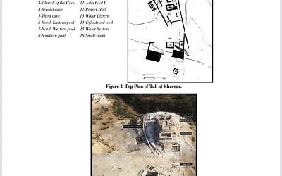
What prompted this hypothesis was the combination of features on the excavation plan: a water supply system, two pools on the northern side and caves on the slope. Could three descriptions in the Copper Scroll refer to the same landscape?
Three accounts of the landscape
1. Tell al-Kharrar (Wadi al-Kharrar / Al-Maghtas). The site lies east of the Jordan River on a hill of Lisan marl surrounded by springs. Traditions associate the area with Joshua’s crossing of the Jordan and Elijah’s ascent to heaven. In Christian tradition, it forms part of “Bethany Beyond the Jordan,” the area where John the Baptist was active. The Al-Maghtas complex has two archaeological centers: Tell al-Kharrar, also known as Elijah’s Hill, and the area of the churches of John the Baptist near the river. “Al-Maghtas” means “the place of baptism.”
2. Kohlit in rabbinic literature. Tractate Kiddushin recounts that Alexander Jannaeus went to “Kohlit in the wilderness” and captured sixty towns. Upon his return, the sages of Israel were served meluhim on golden tables in remembrance of what their ancestors had eaten. If meluhim refers to saltbush, a salt-tolerant plant, the reference raises a question about Kohlit’s surroundings. Could saltbush have grown in the low-lying parts of the region where the campaign took place? The account places the meal after Jannaeus returned, leaving open where the plants were gathered.
The Mishnah also mentions ezov kohli, a kind of hyssop deemed unsuitable for purification rites. The resemblance between the names Kahlat and Kohlit raises the possibility that the scroll identifies a particular tell within the wider region where the rabbinic account places Jannaeus’s campaign.
3. Kahlat in the Copper Scroll (3Q15). The name Kahlat appears in several descriptions of places. Three entries are central to this proposal. Section 4 mentions a tell, a water channel and an immersion cavity. Section 11 refers to a pool east of Kahlat. Section 60 describes a cavity north of Kahlat with a north-facing entrance and graves at its opening.
The ancient Dead Sea level
According to Tzipora Klein’s reconstruction, reproduced in a 1998 regional water resources overview, the Dead Sea reached about 330 meters below sea level in the late Hellenistic period. Revital Bookman and her colleagues reconstructed substantially lower levels. If the higher reconstruction is correct, the rise may have altered the shoreline, the area around the mouth of the Jordan and access from the tell to the lowlands.
If the lake reached the low-lying ground around the tell, inundation by saline water could have increased soil salinity. Once the water receded, the exposed ground may have provided suitable conditions for salt-tolerant plants such as saltbush. If such conditions also existed in Jannaeus’s time, they could provide an environmental context for the mention of meluhim in the rabbinic account of Kohlit. The meeting of river water and lake water may also have shaped the appearance of the landscape, raising the question of whether that landscape had any bearing on the name Kahlat.
The difference in elevation between the tell and the lower floodplain, known as the Zor, matters for the question of where the baptism took place. Establishing when the lake peaked and when it receded would help us assess which water sources and crossings were accessible in John’s time. It would also help us consider whether activity centered on the tell and its springs or near the ancient channel of the Jordan.
The Roman road from Jericho to Heshbon and Beit HaMiddot
The excavation reports note that the Roman road from Jericho to Heshbon passed through the Wadi al-Kharrar area. The tell’s location near a crossing between the two banks of the Jordan raises the possibility that agricultural produce and tithes from east of the river passed through the area on their way west. The mention of vessels for priestly contributions and of tithes in Section 4 raises the question of whether the site also served an administrative function involving collection, measurement or storage.
This setting also gives geographical context to the tradition of John the Baptist’s activity. A crossing used by travelers and pilgrims could help explain why people gathered between the tell and the river.
Comparing Entries 4, 11 and 60 with the excavation reports
Section 4 — The top of the tell, the water channel and the immersion cavity. The scroll mentions an opening on the northern side of the channel and a distance of six cubits in the direction of the immersion cavity. Excavations documented pools, channels and clay pipes used to convey water. Taken together, these features raise the possibility that an earlier immersion installation was connected to the tell’s water system.
Section 11 — The northeastern pool. The scroll directs attention to the northern corner of a pool east of Kahlat. The excavation plan shows a northeastern pool (feature 6), with damage to part of its floor and western wall. The excavators interpreted a shaft uncovered in the area of the pool as a Byzantine well. The possible correspondence with the entry rests primarily on the pool’s position relative to the tell.
Section 60 — The northern cavity and the graves. The scroll describes a cavity with a north-facing opening and graves at its entrance. It identifies the cavity as the location of a copy of the text. Caves were documented on the slope of the tell, including one beneath the northwestern pool. Some of the caves were used by monks, raising the possibility that some of these spaces were cut earlier and repurposed in the Byzantine period.
The chronological gap and the coins of Agrippa
Most of the visible structures on the tell, including the churches and mosaics, date to the Byzantine period. The excavation reports state that pottery and coins ranging from the early Roman to the late Byzantine period were recovered from the well fill. A 2012 article, drawing on Wilken, describes a rock-cut tomb opposite the southern slope that reportedly contained two oil lamps and three coins from the reign of Agrippa I. The account offers a possible indication of burial activity around the tell in the first century CE.
What happened between the early Roman activity and the construction of the Byzantine complex? The retreat of the Dead Sea and changes in the Jordan’s course could have altered access routes and the use of different parts of the site. Such changes may help explain why some Byzantine commemorative buildings were erected near the river, while the springs and water installations on the tell remained part of the baptismal landscape.
What the proposed identification could tell us
Identifying Tell al-Kharrar with Kahlat would connect the places described in the Copper Scroll with the plan of a known site east of the Jordan. If “Kohlit in the wilderness” refers to the same region, the account of Jannaeus’s campaign could add historical context. Reconstructing the lake level and the river’s course could shed light on a further question: where within this landscape did the baptism take place? Even if it took place on the banks of the Jordan, the tell above the river could still be the Kahlat of the scroll.
Could a site known today for its baptism tradition also preserve traces of a place mentioned in the Copper Scroll and rabbinic literature?
Related Topics
Related Posts