
Intersection of Science and Policy
Jerusalem Snow Versus Global Warming
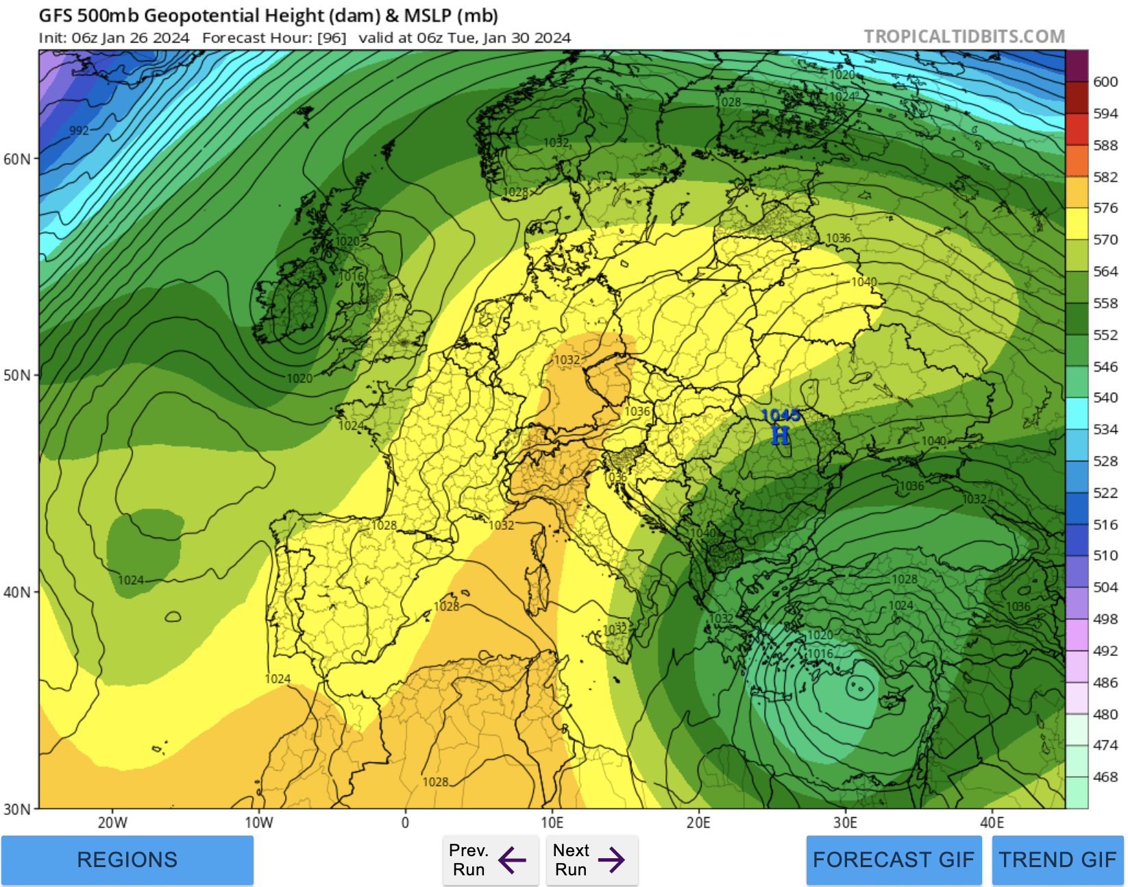
Tropical Tidbits 500 mb height map for This Tuesday morning (Used with Permission)
Like warmed over tea that goes “stale,” storms that linger over the Mediterranean Sea are not likely to produce snow in Jerusalem. Such is the most likely case next Tuesday and Thursday.
Our current bout of rainy and cold weather has been the subject of much discussion in our weather group, between Yaakov Cantor, Jonathan Hoffman, and I — perhaps aptly named “Israel Winter Weather.” I say perhaps aptly because the whole purpose of our group is to make it snow, so “Israel Snow Weather” might have been more appropriate.
However, no matter how much we talk and argue, it’s hard to fight global warming. The picture above shows our upcoming “winter” storm that will affect us this Tuesday into Thursday. Notice, there are two aspects of the “situation.” First, the center of the storm, as indicated by the lower heights, is west of Cyprus. The lower heights indicate colder mean atmospheric temperatures. Second, we don’t see even really lower heights like our present to our north (light blues or even blues on the map).
In the old days, when I first moved to Israel, the “gold standard” for snow in Jerusalem was temperatures below -25 Celsius at 500 mb, below -10 Celsius at 700 mb, and below 0 Celsius at 850 mb. However, with global warming, the heights at which these atmospheric layers occur has risen, since the mean temperatures of the atmosphere has risen (or the density of the air below 500 mb has fallen a tad).
Why do we care about these temperatures? Colder 500 mb temperatures means the greatest chance for thundersnow. Colder 700 mb temperatures means good Dendritic snow growth. Colder 850 mb temperatures means that the cold air is very close to the streets, buildings, and parks of Jerusalem. This means that if a lonely snowflake makes its way downwards from the 850 height level (or even many such flakes), they can parachute right to the ground, and end up as a snowball or snowman, or even grace the Kotel.
But, in our “new, “warmer world, the distance to the earth’s surface is longer, and the journey much more perilous. Some snowflakes may be seen in the air, but most may end their frozen lives as just raindrops.
It’s not really sad in the scheme of things and considering our situation. Yet, snow does tend to brighten our day and bring a smile to the children of Jerusalem.
Getting back to the reality of today, most of the current ensemble forecasts show a more westerly track of the cold air before it reaches us about the 31st of January. Some members do suggest a more easterly track (still) and some do show it cold enough (low enough heights) for snow in Jerusalem. But, they are definitely in the minority.
Right now, the most likely scenario is continued rain, with possible snow in Gush Etzion, and more likely snow in the Galilee and especially the higher heights of the Golan. The timing for this is Tuesday night (the 30th of January) into Thursday morning (February 1st) of next week. Until then, heavy rain is expected Erev Shabbat into Shabbat, lighter rain on Shabbat, and then Monday through Thursday, generally, with gusty winds.
As for the end of the week, we’re entering a period when there will be a transition to a more “blocky” type of circulation pattern (static), and Yaakov spent several WhatsApp messages noting that some of the models are now indicating that we may have another snow chance than currently indicated actually late next week.
Shabbat Shalom!
Related Topics