
One of the People
Jewish History: Tribal Boundaries
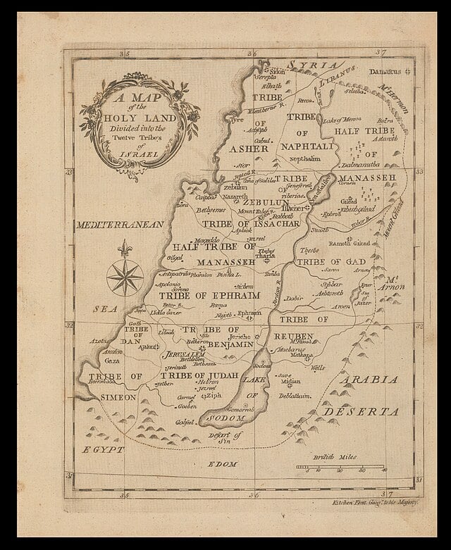
A map of the twelve tribal territories of Israel. Wikimedia Commons.
During the period of the Israelite repatriation to the Land of Israel (c. 1273–1245 BCE), the 12 tribes—Reuven, Shimon, Levi, Judah, Yisakhar, Zvulun, Dan, Naphtali, Gad, Asher, Joseph (Ephraim and Menasheh), and Benjamin—were allocated lands on both sides of the Jordan River and the Salt (Dead) Sea. These allocations were typically discrete territories; owing to its unique sacerdotal duties, however, the tribe of Levi did not receive contiguous territory, but rather 48 cities—including 13 Kohanic (priestly) cities and six cities of refuge—throughout the Land of Israel.
The tribal territories are demarcated in the Tanakh (Hebrew Bible), particularly in the books of Numbers (32, 34–35) and Joshua (13–19). As with its several and sundry descriptions of the borders of the Land of Israel (maximal, medial, and minimal), Scripture is often imprecise with its delineations of the tribal boundaries: the descriptions are rarely straightforward and typically comprise a series of cities and towns, along with their immediate environs, belonging to the respective tribes.
The subject is further complicated for a number of reasons, including: certain tribes possessed loci within the territories of other tribes (e.g., Menasheh in Asher and Naphtali, Ephraim in Menasheh, Gad in Reuven); the allotments were official inheritances not always fulfilled in practice due to the ongoing presence of existent Canaanite populations; the Neo-Philistine invasion of the southern Levant (c. 1175 BCE) carved out from the tribal territory of Judah the coastal region of Philistia, a pentapolis of five city-states (Ashdod, Ashkelon, Gaza, Gath, Ekron); part of the tribe of Dan (600 Danites girded with weapons) migrated early in the era of the Judges (c. 1228–1020 BCE) northeastward toward the sources of the Jordan River in the Beit Rehov Valley in Upper Galilee; following the division of the United Monarchy (931 BCE), part of the tribe of Shimon apparently migrated northward to the Kingdom of Israel (though many of these Shimonites subsequently returned) and, later, another part migrated to Gdor (Gerar?) and southeastward to Mount Seir (where 500 Shimonites struck down remaining Amalekites); over the course of time, certain border towns shifted from one tribe to another (e.g., Beit El and Jerusalem, both formerly within Benjamin, were later absorbed into Ephraim and Judah, respectively), and indeed in some instances an entire tribal territory was incorporated into that of another (e.g., Shimon and Benjamin into neighboring Judah); and some modern identifications of biblical sites (e.g., the Yiftah-el Valley, Ramot-Gilad) germane to the tribal boundaries remain either tentative or elusive.
What follows is a précis adumbrating the original boundaries of the tribal territories in both Cisjordan (west of the Jordan River) and Transjordan (east of the Jordan River).
Reuven
North: Heshbon Stream
South: Arnon River
East: wasteland east of the Way of the Wilderness road and the Kideimot Wilderness
West: Jordan River/Salt (Dead) Sea
Gad
North: Lake Kinneret (the Sea of Galilee)
South: Heshbon Stream
East: northeastern Gilad and Ammon (west of Rabbat-Ammon)
West: Jordan River
Menasheh (eastern)
North: Mount Hermon
South: Yabbok River
East: Aramean Desert (east of Edrei)
West: Jordan River/Lake Kinneret/northwestern Gilad
Menasheh (western)
North: The Jezreel Valley
South: Nahal Kanah
East: Jordan River
West: Mediterranean Sea
Ephraim
North: Mikhmittat, Tappuah, Nahal Kanah
South: Plain of Jericho to Beit El (Luz), Beit Horon, and Gezer
East: Jordan River
West: Mediterranean Sea
Dan
North: Yarkon River
South: Sorek Valley/Philistia
East: Ayalon Valley/the Shfeilah
West: Mediterranean Sea
Benjamin
North: Jordan River (north of Jericho) up the central hill country to Beit El then down to The Way to Beit Horon
South: Jordan River (north of Beit Hoglah) up the central hill country to Jerusalem then to the north of Kiryat Ye’arim
East: Jordan River
West: south of Lower Beit Horon to north of Kiryat Ye’arim
Judah
North: the mouth of the Jordan River [to the Valley of Akhor, Ben Hinnom Valley (just south of Jerusalem), Water of Nephtoah, Kiryat Ye’arim, and Sorek Valley incl. Yavne’el (Yavneh)] to the Mediterranean Sea
South: Tzin Desert (and south of the Salt Sea, Scorpion Pass, and Kadesh-Barnea to the Brook of Egypt) until the Mediterranean Sea
East: Salt (Dead) Sea and the mouth of the Jordan River
West: Mediterranean Sea [between Yavne’el (Yavneh) and the Brook of Egypt]
Shimon
North: Between Gerar and Kiryat Seifer
South: Sharuhen to Hormah
East: from west of Kiryat Seifer down to Hormah
West: Tziklag to Sharuhen (Gerar Brook to Bsor Brook)
Zvulun
North: Yiftah-el Valley (or north of Hannaton)
South: Kishon Brook and Jezreel Valley to Mount Tavor
East: Mount Tavor to Rimon and Neiah (or Yodefat mountain range)
West: Yiftah-el Valley (or north of Hannaton) to Kishon Brook
Yisakhar
North: Mount Tavor and Yavniel Stream (Nahal Yavniel)
South: Jezreel Valley incl. Ein Gannim (Beit HaGan/Ginat/Jenin)
East: Jordan River
West: Nazareth mountain range and Jezreel Valley
Naphtali
North: Lebanon Mountains
South: Mount Tavor to the Jordan River
East: Jordan River and Lake Kinneret
West: Lebanon Mountains down (west of Beit Anat and Beit Shemesh) to Yodefat mountain range then arcing further down to Mount Tavor
Asher
North: Tzidon to the southern Lebanon mountain range
South: Kharmel mountain range
East: Kharmel mountain range (and across Yiftah-el Valley, then past Khabul) to the southern Lebanon mountain range
West: Mediterranean Sea
What, then, is the relation between the tribal territories collectively and the several sets of borders of the Land of Israel? In point of fact, the tribal territories most closely conform to the minimal borders of the Land of Israel, namely “from Dan to Be’ersheva” or “from Be’ersheva to Dan”; interestingly, they also share much in common with the prophet Ezekiel’s envisioned borders (minus, apparently, much of Transjordan and the eastern tableland).
Tribal Israel evolved into the United Monarchy of Israel (1030–931 BCE) that consolidated the nation. Today, the State of Israel possesses much but not all of the tribal territories: most of eastern Judah, Benjamin, Ephraim, and western Menasheh remain disputed and predominantly inhabited by Palestinian Arabs, while the Transjordanian and translacustrine territories of Gad and Reuven remain occupied by Jordan, and eastern Menasheh (excepting the western Golan) by Syria and Jordan.
Related Topics
Related Posts