
Geopolitical Analyst: Bridging Somaliland & Israel to the world
The Red Sea Map Has Changed. Western Strategy Has Not.
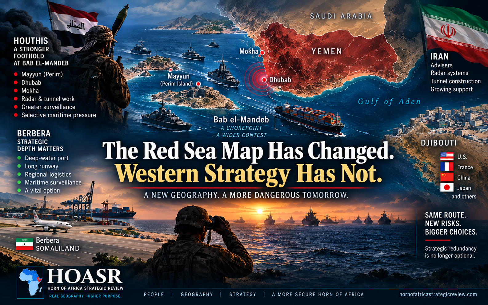
The Houthi breakthrough around Bab el-Mandeb is altering the strategic geography connecting Yemen, Djibouti and Berbera. Original HOASR infographic.
The Houthi breakthrough at Bab el-Mandeb should force Washington and its partners to reconsider an increasingly outdated Red Sea security architecture—and the strategic value of Berbera within it.
The most important lesson from the Houthi advance toward Bab el-Mandeb is that the security architecture surrounding one of the world’s most important maritime corridors has failed to keep pace with the geography it was supposed to protect.
Mayyun, Dhubab and the Yemeni coastline overlooking the strait are becoming increasingly important pieces of a larger contest involving Iran, Saudi Arabia, Israel and the United States. Yet Western strategy remains heavily dependent on arrangements designed for a different Red Sea.
For years, the international response to the Houthis has concentrated on intercepting missiles and drones, escorting commercial vessels and striking launch sites when attacks became intolerable. Those measures addressed the weapons coming toward the sea without sufficiently addressing the geography from which maritime coercion could eventually be used. The Houthi advance has exposed the weakness of that approach. A missile can be intercepted; a strategically positioned and increasingly fortified coastline presents a much more complicated problem.
Mayyun illustrates the difference. The island sits inside Bab el-Mandeb, while Dhubab provides mainland fortification beside it and Mokha extends the military geography farther north. Possession of these positions empowers the Houthis to improve their ability to observe shipping, threaten selected vessels and impose uncertainty on maritime traffic without attempting the far more difficult task of closing Bab el-Mandeb completely.
That is why recent reports of Iranian specialists examining radar positions and tunnel construction deserve more attention than another battlefield headline. AFP reported on September 19, citing Houthi military sources, that personnel associated with Iran’s Islamic Revolutionary Guard Corps had inspected positions around Bab el-Mandeb and Mokha and were involved in discussions about radar installations and underground facilities.
The reporting does not establish that an integrated surveillance network is already operating, and those claims still require continued scrutiny. But if the Houthis are moving from capturing territory to hardening it, the strategic problem is entering a different phase.
That combination is deadly. Geography provides proximity, radar can provide awareness, underground facilities can improve survivability, and missiles and drones provide reach. None of those capabilities alone gives the Houthis command of the Red Sea. However, combined and sustained over time, they could create an increasingly sophisticated environment for selective maritime threats around the southern gateway to the Suez route.
This is where Western policy risks confusing the absence of catastrophe with the presence of security. Bab el-Mandeb remains open. Commercial vessels continue to transit the waterway. The Houthis have not established absolute control over international navigation. But waiting for the strait to close before concluding that the strategic environment has changed would be precisely the kind of bureaucratic thinking that allows temporary military gains to harden into permanent realities.
Time now favors whoever can alter the terrain fastest. Tunnels can be excavated, surveillance equipment installed, supply routes established and defensive positions reinforced while governments debate mandates and alliances. Strategic restraint is sometimes necessary, particularly when escalation could widen an already dangerous regional conflict. But restraint must preserve options; otherwise, it becomes inertia while an adversary gets the opportunity to change the operating environment.
Saudi Arabia should understand this better than most. Riyadh spent decades developing an energy corridor toward the Red Sea partly to reduce its dependence on the Strait of Hormuz. The logic was straightforward: if the Gulf became dangerous, Saudi oil could move westward toward Yanbu and reach international markets through the Red Sea. A stronger Houthi position around Bab el-Mandeb exposes that vulnerability at the other end of that strategy.
The kingdom therefore faces an uncomfortable strategic circle. Trouble at Hormuz increases the value of the Red Sea route, while instability at Bab el-Mandeb reduces the security of that alternative. Missile defense over Saudi territory cannot solve this problem by itself. Neither can naval escorts if the underlying military geography around the choke point continues to deteriorate.
The same reality confronts Israel. Maritime access to Eilat ultimately depends on passage through Bab el-Mandeb. A Houthi presence capable of combining observation with selective targeting therefore creates strategic pressure hundreds of kilometers from Israel’s coastline. Israel does not have to lose access to the Red Sea completely for that vulnerability to become significant; uncertainty over whether particular vessels can be identified and targeted is itself a form of leverage.
Across the water, Djibouti remains indispensable. Its location, established infrastructure and concentration of American, French, Chinese and other foreign military facilities make it one of the most important security hubs in the region.
But the Houthi breakthrough also exposes the weakness of concentrating so much international military infrastructure directly opposite an increasingly militarized Yemeni coastline. An indispensable base can remain indispensable while becoming insufficient.
That is where Western strategic thinking should begin moving east. Berbera is not a substitute for Djibouti, and presenting it that way would misunderstand both locations. Its value is redundancy. Berbera lies farther from the immediate Bab el-Mandeb battlespace while remaining connected to the Gulf of Aden maritime system, combining a deep-water port with one of the region’s longest runways and expanding logistics infrastructure.
American military planners have already examined that geography. AFRICOM reported that its commander, General Dagvin Anderson, traveled to Berbera in November 2025 to assess the security environment and review the port’s operational capacity. That visit does not prove that Washington intends to establish a base there. It demonstrates something more relevant to the present argument: the operational value of Berbera was already being examined before the latest deterioration around Bab el-Mandeb.
The construction visible around Berbera airfield has added to speculation. Le Monde reported in July, using satellite imagery and other sources, on substantial work south of the runway and linked it to renewed Emirati military development, while also reporting possible American and Israeli requirements, however, public evidence does not establish an operational American or Israeli base.
Barbera’s strategic case exists without a foreign base. Its port exists. Its runway exists. Its geographic distance from Bab el-Mandeb exists. AFRICOM’s interest is documented. What has changed is the environment against which those assets must now be evaluated.
Washington therefore does not face a binary choice between ignoring Berbera and building another Camp Lemonnier. Strategic access can take many forms: logistics arrangements, maritime surveillance cooperation, contingency access, intelligence sharing, coast-guard partnerships, exercises and aviation support.
The objective should be to create options before an emergency requires them, not to search for alternatives after existing arrangements come under pressure. Strategic redundancy is ultimately about preserving choices.
This is also where Somaliland’s diplomatic status and its strategic geography increasingly collide. Washington’s Somalia policy has traditionally shaped how far American officials are prepared to go in developing formal relations with Hargeisa. That diplomatic framework cannot simply be wished away. But military geography does not reorganize itself around diplomatic convenience.
The wider lesson extends beyond Somaliland. Hormuz, Yanbu, Bab el-Mandeb, Mayyun, Djibouti, Berbera and Eilat are increasingly connected components of the same security system. Pressure at one point shifts dependence toward another, and vulnerability at one location increases the value of alternatives elsewhere. A Red Sea strategy that treats these places as separate files will repeatedly find itself reacting after the geography has already changed.
The Houthi breakthrough may still be reversed. Yemeni government-aligned forces can regroup, exposed infrastructure can be destroyed and regional alliances can change. But policymakers should not build strategy around the assumption that the previous map will restore itself. The prudent approach is to prepare for a Red Sea in which the southern choke point remains more contested, more militarized and more vulnerable to selective coercion than it was before.
That preparation should include Berbera. Berbera belongs in the discussion because strategic redundancy has become more valuable precisely as Bab el-Mandeb has become less predictable. Ignoring an available port and airfield because the diplomatic file is complicated would place bureaucratic habit ahead of strategic geography.
The lesson from Mayyun is simply this: geography can change faster than policy. Once captured territory is fortified, connected to surveillance and incorporated into a wider military system, recovering the strategic position that existed before becomes considerably more difficult. Washington does not need to accept every conclusion Somaliland draws from its geography, but it does need to recognize the geography itself.
The Red Sea map has changed. Western strategy should change with it.
Selected Sources
Associated Press — Houthi control and maritime pressure around Bab el-Mandeb. Open source
AFP via Ahram Online — Reported IRGC experts, radar preparations and tunnel work. Open source
Financial Times — Houthi offensive and fragmentation among Yemeni government-aligned forces. Open source
U.S. Africa Command — AFRICOM commander’s November 2025 Somaliland and Berbera visit. Open source
Le Monde — Satellite-imagery reporting on construction at Berbera airfield. Open source
Related Topics
Related Posts