Barry Lynn
Intersection of Science and Policy

A Medicane Arrives

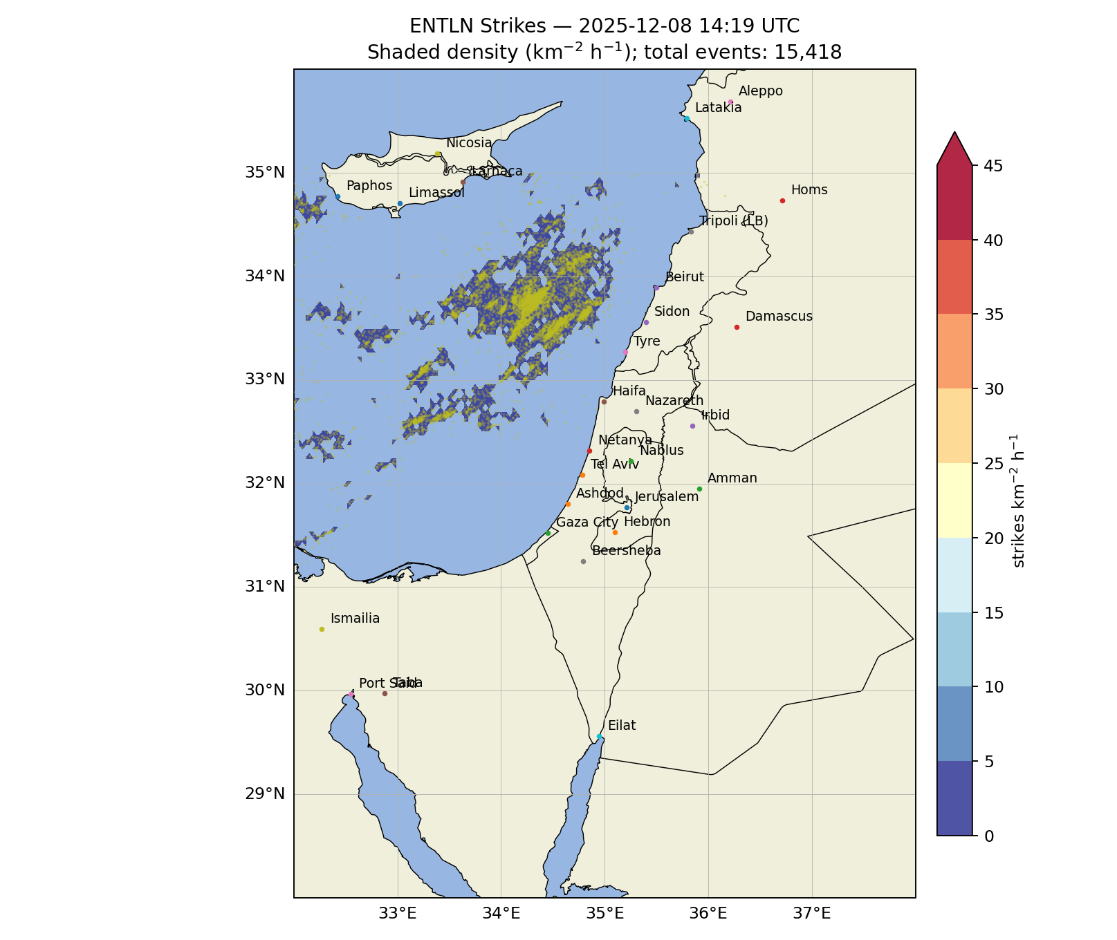
A Menacing Storm Approaches (Weather It Is, AEM)

Medicanes are technically classified as Mediterranean tropical-like cyclones (TLCs), and one is now on its way toward our region. To follow the storm’s arrival in real time, you can visit our updated lightning display at weather-it-is.com/lightning.

While they form within the same larger weather patterns that produce our usual winter storms, Medicanes fall into a hybrid category because they can go on to develop distinctly tropical characteristics—such as a warm core, an eye-like center, and a symmetric cloud shield. (You can read more details at the bottom of this blog.)

Yaakov Cantor,  a member of our Israel Winter Weather group, warns us that this storm will start soon and last into Shabbat, bringing strong thunder and lightning storms, flooding, high winds, and even snow on Mount Hermon.

He further notes that one of the most unusual aspects of this system is its expected semi-tropical (hybrid) structure with a warm core. This means that temperatures in the lower and middle atmosphere near the center of the storm will be a few degrees warmer than in the surrounding environment. In contrast, most winter storms in Israel are cold-core, with colder temperatures near the storm center than at its edges.  Due to the severity of the event, Yaakov prepared this weather outlook.

Rainfall Outlook

• Mon–Tue: Locally heavy rain will focus along the north and central coasts.
• Wed: As the storm strengthens and receives an additional surge of upper-level energy from the north, rain will spread into the foothills (Shfela), with lighter precipitation in the Central Mountains.
• Thu: Rain becomes more widespread and heavier, expanding across the Central Mountains and into eastern Israel.
• Fri: Rain becomes more scattered and localized, with the heaviest amounts likely from the southern coast into the Negev.

Flooding and Winds

Significant flooding is likely in urban coastal areas from Wednesday into Thursday, and in the Negev and Judean Desert from Thursday into Friday.
Locally strong wind gusts are expected from Wednesday afternoon through Thursday.

Snow

Snow is expected on the peak of Mount Hermon from Tuesday evening into Friday. Lower elevations on the mountain will likely be too warm for meaningful snow accumulation.

Longer-Range Outlook

There is potential for another significant precipitation event around the middle of next week.

Temperatures are expected to average colder than normal over the next 10 days.
For those interested, here are some further details about Medicanes.  Stay safe!
  • Formation Conditions: They often form when a cold air mass in the upper atmosphere moves over the relatively warm Mediterranean Sea, creating significant atmospheric instability and deep convection (thunderstorms).
  • Core Structure: As the storm intensifies and convection organizes around a central low-pressure area, the latent heat released from condensation creates a warm core that can extend through much of the troposphere.
  • Intensity: While generally smaller and weaker than typical Atlantic hurricanes, the strongest medicanes can reach Category 1 hurricane strength on the Saffir-Simpson scale
About the Author
Dr. Barry Lynn has a PhD in Environmental and Atmospheric Sciences. He has an undergraduate degree in Biology. He is a researcher/lecturer at the Hebrew University of Jerusalem, and is the CTO of Weather It Is, LTD, a weather forecasting and consulting company.
Related Topics
Related Posts
Sign in or Register
Please use the following structure: example@domain.com
Or Continue with
By registering you agree to the terms and conditions
Register to continue
Or Continue with
Log in to continue
Sign in or Register
Or Continue with
check your email
Check your email
We sent an email to you at .
It has a link that will sign you in.