
Intersection of Science and Policy
Oh My! Oh My! Terrible Storm
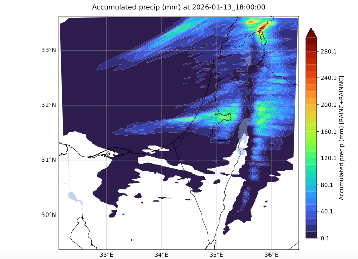
WRF Forecast Precipitation Through Wednesday (Barry Lynn/Hebrew University)
There are winter storms — and then there are winter storms that defy description. This one does not even have a name, but it should.
A deep trough dropping southward into the eastern Mediterranean will spin up an exceptionally powerful and long-lasting storm, affecting the region from Monday afternoon through late Tuesday.
Forecast rainfall totals in the Jerusalem area are approaching 150 mm. The WRF model indicates that the most intense band of precipitation will extend from Israel’s southern coastal cities—including Ashdod and Ashkelon—eastward into the Jerusalem Mountains. This raises serious concern for another lake and flooding event in Gaza, as well as significant flooding in these cities.
During the most intense hours of precipitation—late tonight into early Tuesday—temperatures will fall to just above freezing in the Jerusalem mountain areas. Ice pellets and even snow are possible at higher elevations around Jerusalem. Given the expected precipitation intensity, ice pellets are likely to accumulate on the ground, creating hazardous conditions through the night and into the morning hours.
Winds will be strong and persistent along the coast, averaging around 50 km/h, with higher gusts. These winds will also penetrate inland, reaching the Galilee Mountains. In the Jerusalem Mountains, winds may average 75 km/h, with even stronger gusts.
Snow is also expected on the Golan Heights.
This is an exceptionally dangerous and high-impact storm.
Related Topics
Related Posts