London based entrepreneur, cybersecurity analyst doing a PhD in AI
On Urban Planning – Multiple use city spaces.
The Two-Job City
How Data Science, Dual-Use Infrastructure and Better Planning Can Build Cities That Waste Less
Cities have a space problem.
Land is expensive. Roads consume enormous areas. Roofs sit beneath sunlight while rainwater is sent immediately into drains. Walls absorb heat. Car parks bake in the sun. Streetlights illuminate roads at night and spend much of the day standing idle.
Perhaps the problem is not simply that cities consume too much.
Perhaps cities ask too little of what they already have.
A roof should first keep a building dry. But it can also generate electricity and collect rain.
A wall should enclose a building. But it can also generate power, provide shade or support vegetation.
A streetlight should illuminate a road. But in the right location it can also carry solar generation, environmental sensors, communications equipment or, where measured wind conditions justify it, a small turbine.
A car park can store cars while a solar canopy shades them and produces electricity.
A drainage corridor can carry stormwater while functioning as planted public space and temporary flood storage.
This is the Two-Job City:
Every urban asset should perform its primary job well—and then be tested for a useful second job and possible multiple tertiary uses.
The important word is tested. The principle is not to cover cities with fashionable technology. It is to make existing urban space work harder while consuming fewer additional resources.
That requires a second idea:
data before concrete.
The future city should not simply be designed, built and defended afterwards. It should be forecast, mapped, simulated, piloted, measured and changed.
1. Plan Before Scarcity: The Model of Yusuf عليه السلام
One of the clearest examples of long-range resource planning in the Qur’an appears in the story of Yusuf عليه السلام.
Egypt faces seven productive years followed by seven severe years.
Yusuf عليه السلام does not wait for scarcity to arrive.
He uses abundance to prepare for it:
“You will plant grain for seven consecutive years, leaving in the ear whatever you will harvest, except for the little you will eat. Then after that will come seven years of great hardship which will consume whatever you have saved, except the little you will store.”
— Qur’an 12:47–48. (Quran.com)
The next verse then anticipates recovery after the crisis. Qur’an 12:47–49
This is agricultural planning, not a modern zoning code.
But the underlying logic is remarkably useful:
observe → forecast → conserve → prepare → endure → recover.
That is resilience.
A city expecting hotter summers should not wait for heat emergencies before creating shade.
A district expecting population growth should not wait for schools and transport to become overloaded.
A flood-prone neighbourhood should not continue treating every roof, road and car park as a surface from which water must be expelled as quickly as possible.
If future electricity demand will be driven by cooling, planners should ask today whether buildings can reduce heat gain before simply installing more air conditioning.
The lesson is not that forecasts are infallible.
They are not.
The better principle is:
When a future constraint is reasonably foreseeable, today’s city should leave room for it.
That means governments should stop producing one “official future”.
Model several.
What if population growth is low?
What if it is high?
What if peak summer temperature rises?
What if rainfall becomes less frequent but more intense?
What if commuting patterns change?
What if commercial districts lose office demand but gain residential demand?
A resilient city is not one whose planners predicted everything correctly.
It is one that can continue functioning when they did not.
2. Begin With People and Protect the Public Way
Urban planning can become fascinated with objects.
Buildings.
Bridges.
Railways.
Sensors.
Towers.
But the starting layer of a city should be human need.
People need shelter, movement, safety, access, health, economic opportunity and places where ordinary life can occur.
There is a particularly direct Prophetic precedent concerning the public realm.
Abu Hurayrah رضي الله عنه narrated that the Prophet Muhammad ﷺ ruled that, when there was a dispute over a public way, seven cubits should be left as the roadway. The same principle is preserved in both Sahih al-Bukhari and Sahih Muslim. (Sunnah)
Sahih al-Bukhari 2473
Sahih Muslim 1613
Seven cubits is not a modern highway standard.
That would miss the point.
The principle is that the common way has a protected claim. Private development cannot simply consume everything and leave whatever remains for public movement.
The Sunnah adds another principle. Abu Barzah رضي الله عنه asked the Prophet ﷺ for something beneficial to practise. He replied:
“Remove the troublesome thing from the paths of the Muslims.”
— Sahih Muslim 2618a. (Sunnah)
For a modern planner, that produces an extraordinarily useful question:
What is the harm in this public space?
Sometimes it is literally an obstruction.
Sometimes it is a pavement a wheelchair cannot use.
A road children cannot cross safely.
A junction with repeated collisions.
A bus stop exposed to extreme heat.
Standing water after rain.
A cycle route that disappears precisely where it becomes dangerous.
A public route that feels unsafe after dark.
This suggests a hierarchy for urban planning:
Safety first. Access second. Function third. Efficiency fourth. Appearance fifth.
Beauty matters.
But a beautiful smart district that people cannot comfortably walk through is not a smart city.
3. Give Every Surface a Second Job
Once the public realm is protected, planners can ask more from the surfaces already occupying the city.
Start with the roof.
A roof receives two potentially valuable resources:
sunlight and rainfall.
Building-integrated photovoltaics can make components of the building envelope perform architectural functions while also generating electricity. A 2025 review in Nature Reviews Clean Technology describes BIPV as technologically mature and explicitly defines its value through that dual architectural-and-energy role. (Nature)
The same roof can collect rainfall.
That water does not automatically need to become drinking water. Depending on treatment and local regulation, it might instead serve irrigation, toilet flushing, cleaning or controlled stormwater storage.
So one surface can potentially perform three functions:
protect the building,
produce electricity,
capture water.
Then consider the façade.
High-rise cities may have limited roof area per resident, but they possess enormous vertical surfaces.
Some façades can incorporate photovoltaics.
Others can carry external shading.
Others can support vegetation.
A systematic review covering 647 green-wall case studies found that green walls can reduce building energy demand and urban heat, although results vary substantially with climate, orientation, design and scale. (ScienceDirect)
That qualification matters.
A giant living wall that consumes large quantities of treated drinking water in a dry climate may simply exchange an energy problem for a water problem.
So the useful metric is not:
How many square metres of greenery did we install?
It is:
How much cooling did we obtain per litre of water, per pound of maintenance and per year of useful life?
Sometimes a simple climbing plant may outperform a complicated mechanically irrigated green wall.
The purpose is not spectacle.
It is performance.
4. The Streetlight Should Become a Platform
The same principle applies to street furniture.
Consider the ordinary lamp post.
It already has height.
A fixed location.
Electrical infrastructure.
Maintenance access.
And thousands of replicas distributed throughout a city.
Why should every pole perform only one function?
Solar generation is an obvious possibility.
Some poles may carry air-quality or weather sensors.
Others can support communications infrastructure.
And in streets where wind conditions genuinely support it, hybrid wind-solar generation may also be useful.
But this is precisely where data science must stop architecture becoming theatre.
Urban wind is highly sensitive to street geometry and wind direction. A 2026 study on streetlight-scale urban wind energy found that the geometry of the street canyon and turbine position materially changed available performance. (ScienceDirect)
So the correct policy is not:
Install turbines on streetlights.
It is:
Measure wind first.
Place anemometers.
Build a digital wind model.
Identify corridors where the resource is strong enough.
Then test a small number.
If the turbine produces little energy after maintenance is included, do not install another hundred because the concept looked impressive in a rendering.
The technology should fit the place.
The place should never be forced to justify the technology.
That principle alone could save governments enormous sums.
5. Cooling a City Without Simply Consuming More
Heat exposes the weakness of single-purpose urban systems.
The conventional response to heat is more air conditioning.
But air conditioning consumes electricity and rejects heat outdoors.
So a more intelligent sequence is:
first prevent heat, then remove what remains.
Shade pedestrians.
Shade glass.
Use solar canopies.
Use reflective materials where appropriate.
Protect airflow.
Plant vegetation where it produces meaningful shade.
Reduce unnecessary heat absorption.
Then use mechanical cooling for what cannot be solved passively.
Mist cooling provides a good example of a technology that can be useful when applied selectively.
Researchers testing a mist-spray cooling system at a prototype bus stop and outdoor environment in Guangzhou reported temperature reductions reaching about 3.1°C in one tested configuration, while humidity increased. (ScienceDirect)
That does not mean a city should continuously spray water into its streets.
Instead, make the bus stop intelligent.
Is somebody waiting?
What is the temperature?
What is the humidity?
Is evaporative cooling likely to work?
Is suitable water available?
Only then activate it.
The same logic can govern other infrastructure.
Streetlights can dim when streets are empty.
Irrigation can respond to soil moisture rather than a clock.
Cooling can respond to occupancy.
Water storage can prepare for an approaching storm.
Buildings can charge storage when renewable electricity is abundant.
The city becomes demand-aware.
That is different from simply making it “smart”.
A smart device collects information.
A useful city changes behaviour because of it.
6. Data Before Concrete
This is where data science changes urban planning.
The old master-plan model can become dangerously linear:
predict → design → approve → build.
Once billions are committed, changing course becomes politically and financially difficult.
A better city operates as a feedback system:
observe → model → design → simulate → pilot → measure → decide.
Singapore’s Urban Redevelopment Authority provides a useful contemporary example. URA says its planners use data analytics, geospatial tools and AI to inform land-use and infrastructure planning. Its ePlanner platform can visualise planning and 3D data, perform sun-shadow, accessibility and line-of-sight analyses, and simulate development scenarios before physical construction. (Urban Redevelopment Authority (URA))
That is the crucial shift:
Test the city digitally before changing it physically.
Even very ambitious projects can benefit from this discipline.
NEOM currently describes development of The Line as proceeding through a “phased, demand-led approach.”(NEOM)
That principle is more important than the particular architecture.
Phase Two should not exist merely because Phase One exists.
It should have to earn permission to exist.
Did people arrive?
Was the infrastructure used?
Did energy demand resemble the forecast?
Did the cooling strategy work?
Did maintenance remain affordable?
Did businesses operate?
Were public spaces actually occupied?
If the answers are weak, change the next phase.
The city should learn before it expands.
The Execution Framework
The complete model can now be reduced to seven clear steps. It develops the earlier Forecast → Map → Protect → Multiply → Test → Prioritise → Scale structure into something a government or engineering authority can actually execute.
- FORECAST — What problem is coming? Government begins with need, not architecture. Model population, housing, heat, rainfall, water, energy, transport, schools, healthcare and economic activity under low, expected and stress scenarios. The output is a City Needs Map showing where failure or scarcity is most likely. The planning logic follows the example of Yusuf عليه السلام: prepare before the shortage arrives.
- MAP — What do we already have? Create a citywide digital inventory of roofs, façades, roads, pavements, lamp posts, car parks, drainage, parks, stations, schools, hospitals and government buildings. Overlay solar exposure, wind, rainfall, temperature, pedestrian movement, water demand, electricity use, flood risk and maintenance access. This becomes the Dual-Use Opportunity Map.
- PROTECT — What cannot be compromised? Apply a public-realm test before adding technology: safety, accessibility, walking, cycling, emergency access, drainage, heat exposure and sufficient public space. The Prophetic roadway ruling gives the underlying principle: the common way cannot simply become leftover space after private development. Remove harm before adding novelty.
- MULTIPLY — Can the existing asset do another job? Apply the Two-Job Test to every major project. A roof becomes weather protection plus electricity or rain capture. A car park becomes parking plus solar shade. A drainage corridor becomes flood control plus landscape. A wall becomes enclosure plus shading, solar generation or vegetation. A streetlight becomes lighting plus sensing or generation. Do not construct a separate object where an existing surface can safely provide the same service.
- TEST — Does it actually work here? Simulate first, then build the smallest useful pilot. Ten lamp posts, not ten thousand. One solar car park. Three rain-harvesting schools. Two heat-responsive bus shelters. Define success before construction: energy produced, water consumed, temperature reduced, people served, downtime, maintenance hours and lifetime cost. Then compare prediction with reality.
- PRIORITISE — Where does each pound do the most good? Technical success is not enough. Combine engineering performance with social need. A cooling project may deserve priority where older residents, children, outdoor workers or people without access to private cooling face greater heat exposure. Government should compare interventions using public benefit per unit of lifetime cost, not prestige or visual novelty.
- SCALE, MODIFY OR STOP — Has the idea earned another phase? If the pilot works, scale it. If it almost works, modify it. If the physical asset is useful but its original function is not, repurpose it. If the evidence is poor, stop. A £5 million pilot that prevents a £500 million mistake is not wasted money. It is evidence-based government working correctly.
That creates a continuous loop:
Forecast → Map → Protect → Multiply → Test → Prioritise → Scale → Measure → Forecast Again
The final step returns to the first.
Because cities never stop changing.
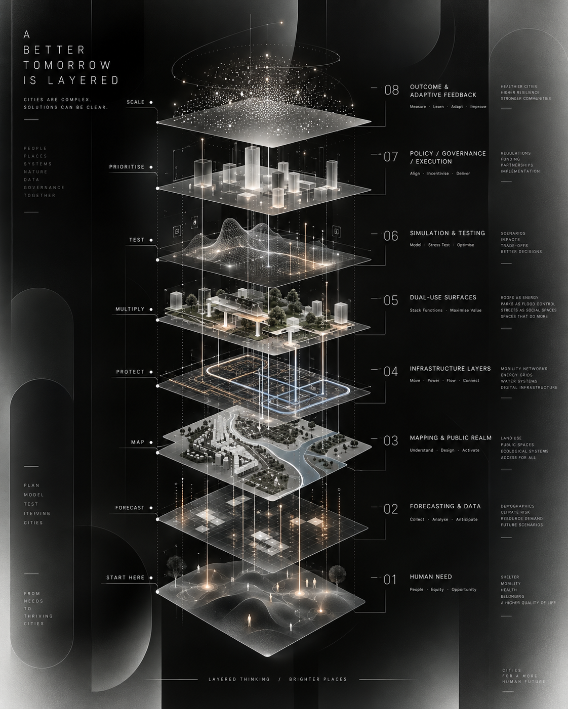
The City as a Layered System
Perhaps this is ultimately the more important insight.
A city should not be designed as a collection of isolated objects.
It is a stack.
At the bottom is human need.
Above it sits data and forecasting.
Then the public realm.
Then transport, water, power and communications.
Then buildings and dual-use surfaces.
Then simulation.
Then governance and execution.
At the top sits something that conventional master plans often neglect:
feedback.
Did the city actually become cooler?
Did flooding fall?
Did electricity demand change?
Did people use the public space?
Did the green wall survive?
Did the wind turbine produce enough electricity?
Did the bus shelter consume too much water?
The answer should determine what happens next.
The purpose of data science is therefore not to make government appear more technological.
It is to shorten the distance between what planners believed would happen and what actually happened.
And the purpose of dual-use design is not to attach technology to everything.
It is to make every intervention carry more value before another intervention has to be built.
That is the Two-Job City.
The roof catches rain and produces power.
The façade protects the building and manages heat.
The tree shades the pavement.
The drainage system becomes landscape.
The car park produces electricity.
The lamp illuminates the street and, where conditions justify it, helps power itself.
The bus shelter responds to heat only when people actually need it.
And beneath all of this is a planning principle illustrated centuries ago in the story of Yusuf عليه السلام:
do not wait for scarcity before beginning to plan for it.
The future city does not need to predict everything correctly.
It needs to plan early, protect people first, use space twice, test ideas cheaply, measure reality and change course before mistakes become permanent.
That may be a far more useful definition of a smart city than simply filling one with technology.
Related Topics