
Intersection of Science and Policy
Unusually Heavy Rains Expected on Sukkot — Our Warming World
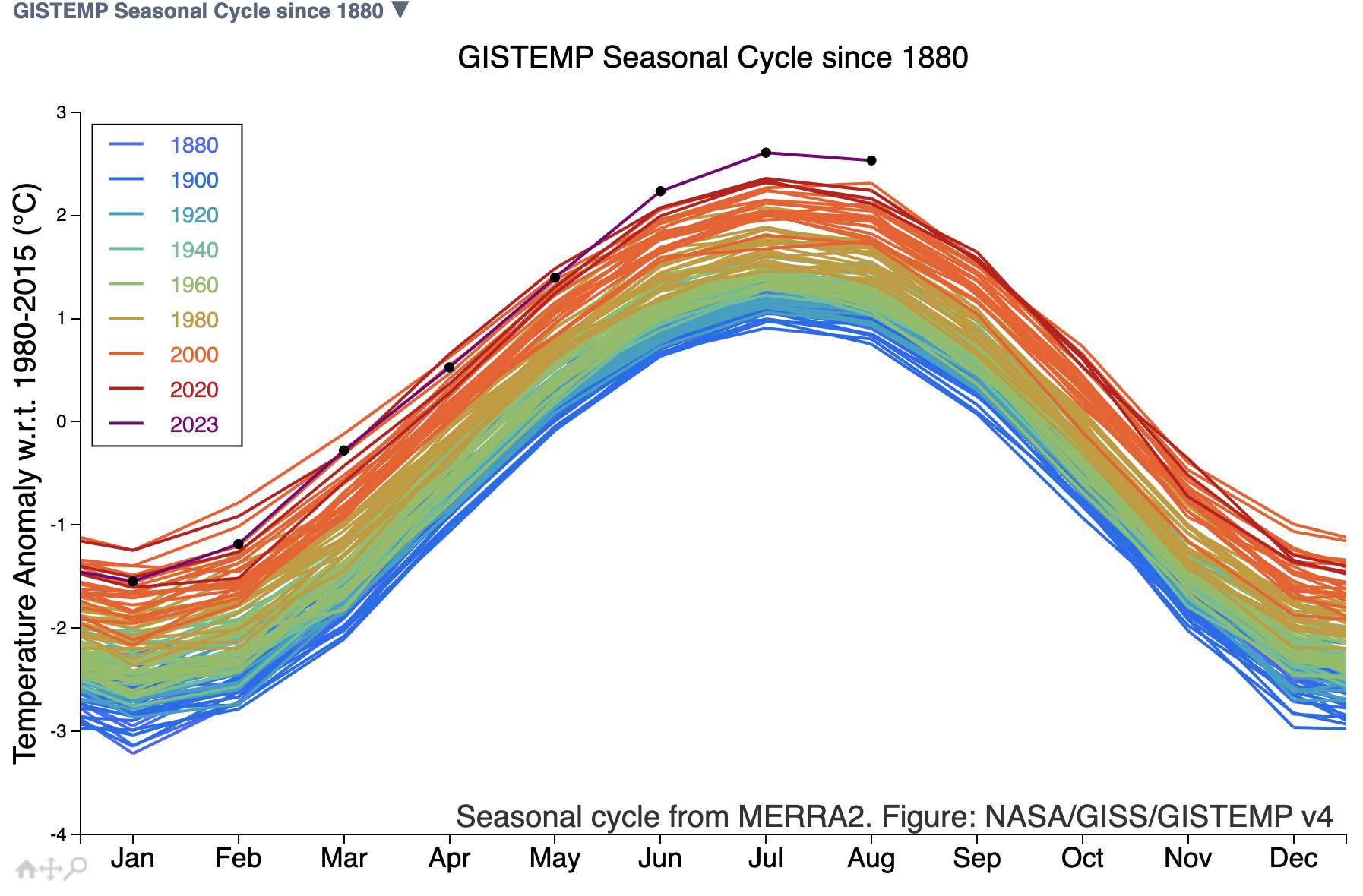
NASA GISS global mean temperatures year by year (see: ttps://data.giss.nasa.gov/gistemp/).
The weather this past Rosh Hashanah and Yom Kippur was the nicest weather I and many of our congregants could remember in a long time. It was sunny, yet delightfully cool. The only so-called “fly in the ointment” was the message I received from a very reputable source that the sun was delayed in setting. Apparently, there were so many prayer groups going and finishing at once that there was a traffic jam of suns needing to set at or near the same times. Fortunately, the delays were minimal, and the post-fast orange juice was as sweet as ever.
We’ve been told by reputable sources that monitor the state of our climate that each year in the past decade was as warm as or warmer than any others, sometimes by just a few or even less than tenths of a degree. This type of information was ridiculed by the “climate change deniers” who claimed that this was simply measurement error. They also claimed that unlike the Arctic, the Antarctic ice coverage was just fine, so no need to worry about melting ice-caps. What does one say, now, though, when the graph above shows that our world’s average temperatures are several tenths (and notably so) above last year’s mean? Or that such temperatures inspire NOAA to create a story documenting the history of last summer’s US hottest days? What does one say when the Antarctic ice mass reached its maximum coverage for the year, but the lowest maximum by a wide margin.
One might wonder if we too are in for some unusual weather and we just might be. In fact, this Sukkot is forecast to be rainy, or at least the first half of Chol HaMoed (the intermediate days of the holiday). But one should also pay attention that a storm currently south of Greece and moving eastward has precipitable water contents almost reaching historical maximum values. In addition, temperatures in the eastern Mediterranean are 1.5 to 3 degrees Celsius above normal (from NCEP data as reported by “The Weather Channel“). Together, this means there is the potential for heavy rain as this system approaches us. In fact, a similar year in the past with such warm sea surface temperatures was the year severe storms toppled a crane in Tel-Aviv, on October 25th, 2015. Hence, the potential for severe weather is real.
Specifically, as noted by Yaakov Cantor of our Israel Winter Weather Group: “Unlike the mid-September system, [there are] no indications of a hybrid/tropical system here… this is a cold-core upper low that forms south of Greece and drifts slowly east [and then] phases with a northern stream trough.” Because of the trajectory of the storm, southwesterly winds ahead of it will likely focus the initial heavy rains along coastal and northern areas. This means, as pointed out by Jonothan Hoffman (same group), that rain or heavy rain will be slower to move into the Jerusalem area, perhaps arriving later Sunday or Monday. In any case, temperatures are going to exhibit a strong downward trend in temperatures for the upcoming week, so our pleasant of today will be behind us.
Our hope is that skies clear up a bit by Wednesday or Thursday, and that folks will carefully monitor the weather before going out hiking or to the sea.
Yet, another storm may (appropriately) come on the holiday of Shemini Atzeret when we all pray for a rainy winter season.
Hag Samaech!
Related Topics
Related Posts