
From Kibbutz to the global stage
Were Qumran Caves and Baptism Sites Temporarily Abandoned as the Dead Sea Rose?
The Dead Sea, Qumran and Baptism Sites: What Might the Ancient Landscape Reveal?
Fluctuations in the Dead Sea’s level may help explain the conditions in which the scrolls survived, the location of baptism sites and the significance of water installations in the Copper Scroll. Yet differences between reconstructions call for a joint investigation by geologists, archaeologists and textual scholars.
What did the northern Dead Sea look like in the days of Herod and John the Baptist? Where was the shoreline? Which areas were accessible, and which caves could have served as repositories for fragile documents?
These are engineering and geographical questions with historical implications. A map based on today’s landscape cannot adequately reconstruct a world in which the lake level, river course, springs and crossing points changed over time.
In my previous articles, I proposed examining the Copper Scroll as a document that may also describe water infrastructure. Building on that approach, I would like to raise a broader question: could reconstructing the ancient hydrological landscape add another dimension to the discussion of the Qumran caves and the baptism sites in the lower Jordan Valley?
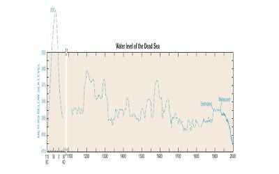
The starting point is Dr. Tzipora Klein’s reconstruction of Dead Sea levels, presented in a 1998 regional water resources publication prepared through Israeli–Jordanian–Palestinian cooperation with assistance from the US Geological Survey (USGS). Its contribution should be considered alongside later studies that present a substantially different picture.
The Copper Scroll and the Hydraulic Landscape
Section 4 of the Copper Scroll links Tel Kahlat with a description containing the terms ha’amah and nikrat ha-tevilah. In the reading I propose, this combination may refer to a water system and an immersion installation, rather than solely to directions for locating a hiding place.
This is a research interpretation, not a proven archaeological identification. The expression nikrat ha-tevilah does not, by itself, establish whether the installation had steps and plastered surfaces, where its water came from or when it operated. The identification of Tel Kahlat also requires independent investigation.
Nevertheless, the combination warrants examination. Could the scroll’s descriptions of distances, openings and water installations preserve information about water management, ritual purification and movement through the landscape?
To investigate that possibility, we must first reconstruct the landscape in which the proposed installations operated.
Klein’s Reconstruction: An Exceptional Rise and a Sharp Retreat
In the curve attributed to Klein and reproduced in the 1998 publication, the Dead Sea rises from approximately 400 meters below sea level to a peak of about 330 meters below sea level during the final decades of the first century BCE. A sharp decline follows, reaching approximately 395 meters below sea level around 40 CE.
According to the accompanying description, the rise amounted to roughly 70 meters, followed by a fall of approximately 65 meters. The text also mentions the flooding of Qumran. This is an estimated reconstruction based on historical evidence and field observations, rather than a continuous record of instrumental measurements from antiquity.
If this reconstruction is correct, its implications are far-reaching. Such a high lake level would have altered the northern shoreline and affected the Jordan’s mouth, access routes and low-lying areas on both sides of the valley.
However, differences in elevation alone cannot establish the boundaries of inundation. That requires a topographic model, a reconstruction of the ancient ground surface and an assessment of erosion, sediment accumulation and changes in the river channel. Research is therefore needed to determine how far north the lake extended and which sites it covered.
The Later Research That Requires Comparison
A study by Revital Bookman, Yehouda Enzel, Amotz Agnon and Mordechai Stein, published in 2004, presents a reconstruction based on sedimentary sequences, shoreline indicators and 46 radiocarbon dates. It reconstructs late Holocene lake levels within a range of approximately 390 to 415 meters below sea level—a range substantially different from the peak shown in Klein’s curve.
This discrepancy must be central to the discussion. The authority of an institutional publication is not sufficient on its own. Conversely, citing a later study is not enough without examining how it addresses the evidence underlying the earlier reconstruction.
We need to establish the evidence for each proposed level, how it was dated and the degree of uncertainty involved. The difference between approximately 330 and 390 meters below sea level fundamentally changes the flooding scenario.
The implications explored here are therefore conditional questions: what would have happened if the higher reconstruction is correct, and what field evidence could confirm or refute it?
The Qumran Caves: Retreating Water Does Not Mean Immediate Drying
One question concerns the marl caves, including Cave 4, where tens of thousands of scroll fragments were discovered.
If the lake reached an elevation that threatened these caves, the investigation must consider both direct inundation and possible effects on groundwater, moisture and salts within the surrounding material.
It is also essential to distinguish between the date of the lake’s retreat and the date when an underground chamber became dry. Groundwater drainage and the drying of porous material can continue after the lake level falls. The duration depends on the properties of the material, the arrangement of the layers, their hydraulic connection to the lake and ventilation within the cave.
Thus, even if the curve indicates that the lake had fallen to approximately 395 meters below sea level around 40 CE, this does not mean that the caves dried immediately. Equally, the graph alone cannot establish that drying continued until the eve of the Great Revolt.
This is a testable question. Do sediments, salt crusts or other traces within and around the caves indicate flooding or damp conditions during the relevant period? Can they be dated and compared with the archaeological record?
The survival of parchment and papyrus may constrain scenarios involving exposure to water and humidity. It does not, by itself, prove that the scrolls were absent from the caves during a particular period. The rate at which writing materials and ink deteriorate also requires investigation; we cannot categorically state that they would have been destroyed within weeks.
If the caves became suitable for storage only after a dated episode of wet conditions, that finding would contribute to the debate over when the scrolls were deposited. It could also be relevant to the hypothesis that libraries were evacuated from Jerusalem, although it would not, by itself, establish the scrolls’ origin.
Al-Maghtas: Examining Layers and Levels Before Drawing Conclusions
The flooding reconstruction may also be relevant to Al-Maghtas, identified in Christian tradition with Bethany Beyond the Jordan.
However, this is not a single topographic point. The World Heritage property includes Tell al-Kharrar and the area of churches near the river. Each has its own elevation, stratigraphic sequence and history. UNESCO describes Roman and Byzantine remains within the property, so any claim of a complete gap in occupation requires careful examination of the excavation reports.
If a particular location stood at approximately 385 meters below sea level, while the lake simultaneously reached approximately 330 meters below sea level, the elevation difference would be about 55 meters. To turn that calculation into a historical account, however, both elevations, their dates and the location’s connection to the lake must be verified.
The investigation must consider the elevation of the ancient layer, rather than only today’s ground surface. It must also seek positive evidence of inundation: dated lake sediments, shoreline indicators or other environmental evidence.
A dated surface showing activity under dry conditions during the proposed period of inundation would be evidence that the reconstruction must address. Lake sediments from the same period could likewise have implications for understanding the site.
The research question, therefore, is which parts of the landscape were accessible in each period, and where human activity and immersion installations could have existed.
Ritual Purity, Salinity and “Living Water”
The hydrological discussion must be accompanied by a precise reading of Jewish ritual law. Saline water should not automatically be equated with water unsuitable for every form of ritual immersion.
Mishnah Mikva’ot 5:4 discusses the status of seas for purification and distinguishes immersion from certain uses requiring “living water.” Salinity alone therefore does not justify categorically ruling out every purification installation.
We need to establish where the water came from, how it was collected or flowed, and which purification practice it served. We must also distinguish the date when the legal sources were compiled from the period we are attempting to reconstruct.
Within this framework, possible installations connected to a spring, aqueduct or reservoir may contribute to the discussion. But we should not assume that every immersion required the same engineering system, or that all groups in the region followed identical purification requirements.
John the Baptist and the Changing Landscape
Changes in the shoreline and river course may help us examine access routes, crossings and possible locations of John the Baptist’s activities.
However, a claim that John moved his activities eastward because of the lake’s expansion would require corroboration from historical documents and archaeological findings. Such an explanation depends on aligning the chronology of landscape changes with the historical and textual sources.
The reconstruction’s contribution would be to define the geographical possibilities: where people could cross, where suitable water was available and where conditions permitted public activity. These questions should be examined alongside the traditions and archaeology.
Why Was Copper Chosen?
Against this background, we can return to the Copper Scroll.
If, as I propose, the scroll contains information about water infrastructure and reservoirs, we may ask whether metal was chosen to give that information lasting durability. We might also ask whether concern about dampness or flooding was among the considerations.
However, we have no direct evidence of the authors’ intentions. The choice of copper may also have reflected the document’s status, its function or a desire to preserve it and protect its contents.
The fact that the Copper Scroll was found in Cave 3 also requires us to distinguish that cave’s conditions from those of the marl caves. A flooding scenario proposed for one cave cannot be applied to all the Qumran caves.
This remains a direction for research: is there a relationship between the document’s contents, its writing material and the environment in which it was stored?
From the Roman Period to the Crusader Period
Medieval lake fluctuations should also be examined through a comparison of the reconstructions. The 1998 publication mentions a rise to approximately 350 meters below sea level between 900 and 1100 CE. The later study likewise identifies a highstand during the Crusader period, but within a lower range of lake levels.
Until this discrepancy is resolved, we cannot conclude that the eastern bank was inaccessible or that flooding dictated the fortification of the monastery at Qasr al-Yahud. Such a connection requires independent evidence concerning construction phases, pilgrimage routes and conditions on the ground.
Nevertheless, comparing lake levels with site histories could provide a useful reciprocal test: buildings can constrain flooding reconstructions, while those reconstructions can help explain the buildings’ locations and functions.
A Proposal for Joint Research
The next step should bring together lake-level curves, precise elevation surveys, excavation reports and sediment analysis. At Qumran, the conditions of inundation, drainage and preservation should be examined in each relevant cave. At the baptism sites, the elevations of ancient layers should be compared with the different lake-level scenarios.
In parallel, the terms in the Copper Scroll and the sources concerning ritual purification require philological and legal examination, distinguishing a possible reading from a proven identification.
I therefore renew my call for Israeli–Jordanian–Palestinian research cooperation, involving international experts and institutions. The disagreement between the lake-level reconstructions gives such a project a clearly defined, testable question.
The ancient hydrological landscape may contribute to our understanding of the scrolls, historical and economic developments, and the baptism sites.
To establish what it can tell us, we must examine the water, the ground and the texts together.
Related Topics
Related Posts