
Courtyards and Characters: Wandering Through Jerusalem’s Living Stories
Why I Traveled to Jordan Just to See a Map
Reflections on how a sixth-century mosaic in Jordan helped solve a Jerusalem mystery and uncover a lost city beneath the Jewish Quarter
")
The author standing in front of the 6th-century Madaba map, pointing to the section that depicts Jerusalem. (photo taken by the author)
The Map I Had Never Seen
For years, I’ve been teaching about a map that I had never actually seen.
If you’ve toured Jerusalem’s Old City with me, you’ve probably heard the story. We stand on the Cardo, the ancient thoroughfare dating back to the Roman Empire, in today’s Jewish Quarter, and talk about a sixth-century mosaic map discovered in a church in a small village called Madaba in Jordan. We talk about how it helped archaeologists understand ancient Jerusalem. We discuss Damascus Gate and a mystery that puzzled people for centuries. We focus on this map, made by Byzantine Christians, that still has something to teach us today.
It’s a story that tour guides love because it has everything: history, archaeology, mystery, and a satisfying ending.
The strange thing was that after all the times I’d told the story, after all the photographs I’d shown, and all the explanations I’d given, I had never actually stood in front of the map itself.
Last week, I finally did.
I had built up this moment in my head for a very long time. It’s not that I expected some profound spiritual experience; it’s just that the Madaba Map had become one of those places that existed on my personal bucket list of things I needed to see. I had spent so much time talking about it that it felt strange not to have set eyes on it.
So when I organized a trip for twelve Israeli tour guides to Jordan, seeing the map was my main motivation.
Sometimes, when you’ve anticipated something for years, reality doesn’t quite live up to the expectation. The Madaba Map didn’t have that problem. It was exactly what I hoped it would be: a remarkable piece of history, sitting quietly on the floor of a church in an off-the-beaten-path Jordanian city that most tourists and guides will never see.
I didn’t walk out of the church feeling transformed (which is probably a good thing). I didn’t suddenly see Jerusalem differently, and I didn’t have an archaeological epiphany. A few days later, I was back in Jerusalem guiding in the Old City, and the Cardo looked pretty much the same as it had the week before.
But I’m still very glad I went.
Jerusalem’s Gates and a Forgotten Mystery
I’m glad I finally saw it because the Madaba Map solves one of Jerusalem’s more interesting little mysteries.
Jerusalem’s gates are like the jewels on the crown that is the Old City walls. They are the adornments that give the walls their character. Over the centuries, the number of gates has changed as conquerors destroyed and rebuilt fortifications, sealed openings for security reasons, or created new entrances to accommodate changing needs.
Each gate has its own story.
And each gate often has several names, depending on who’s doing the talking.
Take Jaffa Gate.
In English, we call it Jaffa Gate because the road leading west from the city eventually reached the port city of Jaffa. In Hebrew, it is Sha’ar Yafo, essentially the same idea.
In the Middle Ages, both Muslims and Crusaders associated this area with King David. Muslims called it Bab Mihrab Dawud (”Gate of David’s Sanctuary”), while the Crusaders referred to it simply as “David’s Gate.”
Today, in Arabic, it is known as Bab al-Khalil, the Gate of Hebron. The road passing through the gate also leads south toward Hebron, known in Arabic as Al-Khalil, named for Abraham, the “Friend of God,” who is buried there.
The same gate, but with different names depending upon different ways of seeing the world.
Then there is the magnificent northern gate.
In English, we call it Damascus Gate because the road heading north eventually reaches Damascus.
In Hebrew, it is Sha’ar Shechem because that road first passes through Shechem, today’s Nablus.
In Arabic, however, it bears a much stranger name: Bab al-Amud, the Gate of the Pillar.
Where’s the Pillar?
If it’s called the Gate of the Pillar, then there has to be a pillar, right? Wrong. There is no pillar, and no trace of one remains. So why the name? I asked several of my Arabic-speaking Palestinian friends. None of them knew. “Was there a pillar there at some point?” they asked.
This was the mystery. For generations, people continued calling it Bab al-Amud, even after the pillar itself, and the reason for the name, had been forgotten.
Mystery Solved
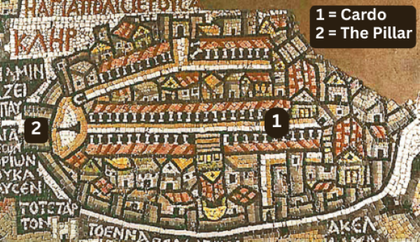
Then the Madaba Map was discovered.
In 1884, during renovations at Saint George’s Greek Orthodox Church in Madaba, workers uncovered a sixth-century mosaic map of the Holy Land. When scholars examined its depiction of Jerusalem, they noticed something fascinating. Just inside the city’s northern gate, exactly where Bab al-Amud stands today, was a large column rising from an open plaza, probably dating back to just after the Roman reconstruction of the city they had destroyed.
Suddenly, the mystery was solved.
The gate wasn’t called the Gate of the Pillar because of some forgotten legend or poetic tradition. It was called the Gate of the Pillar because there had actually been a pillar there.
And it was this sixth-century mosaic floor in Jordan that preserved a piece of Jerusalem’s history long after Jerusalem itself had forgotten it.
That’s a pretty remarkable achievement for a map.
Rebuilding Jerusalem After 1967
The Madaba Map did something else that was perhaps even more extraordinary.
To understand why, we need to leave Jordan and return to Jerusalem in June of 1967.
On Wednesday, June 7, 1967, which was the third day of the Six-Day War, Israel liberated the Old City. For the first time since Jerusalem had been captured and occupied by Jordan in 1948 during the War of Independence, Jews could once again enter the Jewish Quarter. What they found was not a neighborhood waiting to welcome them home.
Quite the opposite. The quarter was largely in ruins.
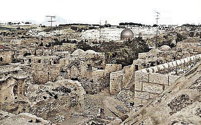
Synagogues had been destroyed. Buildings were damaged and abandoned. Entire sections of the neighborhood were little more than rubble.
The decision facing Israeli leaders was complicated: What should happen next?
Should the Jewish Quarter be rebuilt as a living neighborhood, with homes, schools, markets, synagogues, and children playing in the streets? Or should it become one giant archaeological park, preserving the layers of history buried beneath it?
The answer was: let’s compromise.
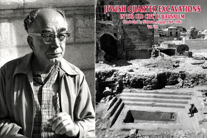
Archaeologists would be given a limited window of time to excavate as much as possible before reconstruction of a new neighborhood began. Leading the dig was the legendary archaeologist Nahman Avigad.
A Map Becomes a Guidebook
And that’s where the Madaba Map enters the story.
The map contains the oldest surviving depiction of Jerusalem. Running through the center of the city is a broad colonnaded avenue. Avigad and his team studied it carefully, using it to estimate where the Cardo should be, how it was aligned, and roughly how wide it had been.
Then they dug. And they found it.
Beneath centuries of accumulated history, exactly where the map suggested it should be, was the Roman Cardo.
It’s hard to miss the historical irony in the story. After 1948, when the Jordanian Arab Legion captured the Old City, they deliberately detonated explosives, and the Jewish Quarter was left in ruins. Nearly two decades later, after Israel regained control of the area in 1967, archaeologists searching beneath that rubble turned, in part, to a map preserved across the river, in Jordan, to help guide their excavations. I love when history comes full circle like that.
Today, hundreds of thousands of tourists walk along portions of that ancient street every year. Most have no idea that one of the clues that led archaeologists to it was preserved not in Jerusalem, but on the floor of a church in Jordan.
What a Gift They Gave Us
As I stood in Madaba looking at the mosaic, I found myself thinking about the people who created it. They couldn’t possibly have imagined that visitors from another country, speaking another language and practicing another religion, would still be studying their work fifteen centuries later.
Yet there we were: a group of Israeli tour guides standing over a Byzantine mosaic in Jordan, discussing archaeology.
Did seeing the Madaba Map change my understanding of Jerusalem? Not really.
Did it make me appreciate the ingenuity of the people who created it, the archaeologists who used it, and the remarkable journey this mosaic has taken through history? Absolutely.
And after years of teaching about it, I’m glad I can finally say that I’ve seen it for myself.
Related Topics
Related Posts